For Registered (purchased) copies only.
While it is simpler to be able to import the DRG maps, it is possible, for those which cannot be imported, to calibrate the maps by hand using 3 Lat/Long points, 3 corners of the map are quite adequate for an accurate calibration.
Use this option to import maps of the supported map image types (TIF, BMP, PNG, JPG, SID, ECW, .....) An example is the USGS DRG raster maps provided by the USA government.
DRG stands for Digital Raster Graphic but are really images of maps in a digital image format which have the map geo-referencing supplied either as a separate file or embedded within the image format.
Examples
Georeference information may also be supplied in a .jgw file for JPG images, a .sdw file for SID images, ....
OziExplorer has various levels for importing these maps and try's to select the method which has the most information to give the best calibration and other parameters.
The georeference information is obtained in this order of priority:
If the FGD file is available then additional information is obtained from it :
If the positions of the corner markers can be obtained then 3 of the corners are used as calibration points. There have been the some instances where the corners of the map stored in the FGD file are in error, this produces an incorrect calibration.
Maps from other sources may have a .XML or .MET file and these serve a similar purpose.
NOTE: If there is no DRG (or similar) file and the image is not Geotiff then the .TFW file is used. This file contains very basic calibration information and is missing some necessary parameters, this process is described fully below, see Importing DRG's with only a .tfw File .
If none of the above are available then the map image cannot be imported and must be calibrated manually.
Geotiff
OziExplorer can extract the georeference information from Geotiff files but it only knows how to decode the information if it is from a known source. Decoding is limited to just the commonly used map projections and grids.
The ability to decode other sources of georeference information in Geotiff files will be added on an as need basis where it is possible to do so.
(To import geotiff images, a geotiff support file (dll) is required. This can be downloaded from our website.)
Select the Import Map/Single DRG Map Option on the File Menu.
Step 1 - Find the image file of the map you want to import.
You need to know the name of the image file of the map you want to import. (It must be one of the supported image types such as TIF, BMP, PNG, JPG, SID, ECW, .....). You will have to find out this name from the information supplied with the CD, I would assume.
Press the OK button and the software will allow you to navigate through your Disk Drives and Directories until you locate the file. If the CD is from the USGS then the file would normally be located in the DATA folder. When you have located the file, select it by double clicking on the name or click on the name and press the Open button.
A METADATA (FGD or other) file may also be available for the image. This is usually located in the METADATA directory of the CD. If you copy the image file to your hard drive the metadata (FGD) file must also be copied and placed in the same directory as the image file.
Step 2 - Specify the Name and Path of the OziExplorer Map file you want to create.
The Map file name will be the same name as the image file but with a .MAP extension. The name of the file can be changed but do not change the extension. Save the file.
Step 3 - The newly created Map will now be opened.
From now on you open the Map by selecting the MAP file using the Load Map from File option. The original image must always be available when opening the map.
The map calibration used can be viewed using the normal Check Calibration of Loaded Map menu option.
Importing all DRG maps on a CD or in a Folder on your Hard Disk
This option allows you to import all DRG maps from a CD but can also Import DRG maps which have been copied to a Hard Disk. If you have a USGS CD and copy the image files to the hard disk you must also copy the fgd files from the metadata directory, place these in the same directory as the tif files.
Select the Import Map/All DRG Maps on CD or Folder Option on the File Menu.
The Import DRG Maps dialog will appear.
Image File Path - The path where the Image files are located. Press the button at the right hand end of the Image File Path field (or enter the Image File Path directly into the field). Select the path (directory) by browsing the disks.
Map File Path - The Path where the created map files will be placed. Press the button at the right hand end of the Map File Path field (or enter the Map File Path directly into the field). Select the path (directory) by browsing the disks.
Use Geotiff if available - If checked and the map images are in Geotiff format and the format is known then the georeference information will be extracted from the image file.
Press the Import button, the maps will be imported.
The new map files are created in the Map File Path you have specified in the configuration.
At the end of the process the number of maps successfully imported (and not imported if any) will be displayed.
The maps are now ready to use, simply open the map you want to view using the OziExplorer Load Map from File menu option.
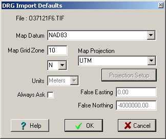
Importing DRG's with only a .tfw File
This also applies to JPG files which have a .jgw file, the jgw file is the same as a tfw file, sdw files can also be used for .SID images, OziExplorer will use these file automatically if it exists.
While not preferred, it is possible to import DRG maps which only have the .tif (or other image format) and a .tfw file. There are a lot of parameters missing such as datum, UTM zone number, scale, map bounding coordinates + others. Most of these can be ignored and set manually after the map is imported.
A dialog will be opened which requests some of this information.
Map Datum - specify the map datum to be used.
Map UTM Zone - specify the zone, 2 digits only. For UTM projection maps the UTM zone number must be known to import the map so you must know this in advance. On the USA DRG maps the zone number is usually provided on the lower left hand corner of the map image, the datum is also provided there. You will need to open the map image in a paint program such as Paint Shop Pro www.jasc.com to view the image.
If you are importing a USA USGS DRG map with just a tfw file and the map image name is in the standard USGS format (example O43107C4.TIF) then OziExplorer will work out the correct UTM Zone number to use from the file name and put it in the Zone field of the DRG Import Options dialog as the default.
Hemisphere - Select the correct Hemisphere (North or South of the equator).
Always Ask - if checked this dialog will be shown for each map imported, if unchecked the parameters entered into the dialog will be assumed to apply to all maps.
Map Projection - Select the map projection which matches the projection of the map you are importing. If it is unknown, it is often provided on the map image. You will need to open the map in a paint program (see above). Some projections are not supported. Some projections require additional parameters (an example is Lambert Conformal Conic), the Projection Setup dialog will popup for you to enter these parameters.
Not all tfw files have the data values exactly as OziExplorer expects, so not all maps can be imported correctly with just the tfw file.