Displaying Lat/Lon and Other Grids
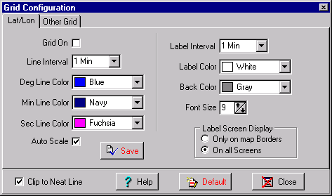
Lat/Lon Grid
The lat/lon grid can be displayed for any map of any scale of any projection. There are some limitations, such as maps crossing the 180 degree longitude and maps which have a border outside a valid lat/lon such as the example world map.
Other Grid
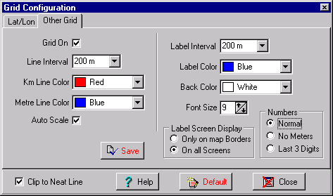
The grid displayed is the one selected in the "Alternate Grid" in configuration. If the UTM grid is selected then the grid displayed on the map is a UTM grid etc.
The display of a grid is very much controlled by the map. It is really only intended for maps of scale say 1:250,000 and below, maps cannot cross a zone boundary (the part displayed on screen anyway). As an example you cannot expect a grid to be displayed on a map which covers a country or the whole world. This does not apply to the UK OSGB (BNG) or the Irish Grid as the format of these grids allow them to be handled as a special case.
I am sure you will find there will be times when the grid will not be displayed on a map.
Parameters
Most of the parameters need no explanation, the ones which are not obvious are decribed below.
Clip to Neat Line - If checked the grid will stop at the neat line boundary which is setup using the corner markers in map calibration. For maps with curved projections odd displays can be noticed if "clip to neat line" is active but these are unimportant.
Auto Scale - If checked as you zoom the map in and out the "Line Interval" will be automatically altered to keep roughly the same line spacing on the display. The line spacing however must be one of the accepted values in the Line Interval selection box.
Numbers
Save - Will save you current settings in the the map file and they become the default for the map.
Label Screen Display - "Only on Map borders" the labels will only be shown on the edge of the map. "On all Screens" the labels will be seen on all screens.
Default - Saves the current settings as the defaults to be used when ever the Grid Config dialog is displayed for a map where a grid is not already configured the defaults will be entered automatically (if you have saved defaults), all you have to do is turn the grid on.
Notes
Printing - A grid will be printed if it is displayed on screen at the time of printing.
Limitations
There is a limit of 200 lines for each grid which can be displayed, after this the lines stop. This is to prevent delays in regaining control (if ever) if too fine a grid is chosen. 200 lines on a screen still allows a very fine grid to be used.
There is a limit of 50 labels which can be used on the grid screen display. When this limit is exceeded the labels will stop being displayed. This limit is not restricting as even with 50 the labels overlay each other anyway and cannot be read.