Project a Waypoint
(or Trackpoint)
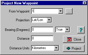
This feature allows a new waypoint or trackpoint to be created at a specified bearing and distance from a known point (waypoint or last trackpoint).
From Waypoint - Select the Waypoint name to project from or the last Trackpoint
... Button - Refresh the waypoint name list.
Projection - Lat/Lon or UTM. With the Lat/Lon projection the calculation are based on the standard calculations using the latitude, longitude and bearing. With UTM projection the latitude and longitude are converted to x,y coordinates using a Transverse Mercator projection, the bearing and distance are applied to these x,y coordinates and the new position calculated. The UTM projection method more closely approximates drawing lines on a map which uses a Transverse Mercator projection.
Bearing (Degrees) - The direction to project from the current position. Select either True or Magnetic reference. The reference does not apply to UTM projection as the bearing is always referenced to the grid.
Distance - Enter the distance in the units specified below.
Distance Units - Select unit of distance to use.
Close - Close the dialog
Project Button - Do the projection and create the new Waypoint or Trackpoint.