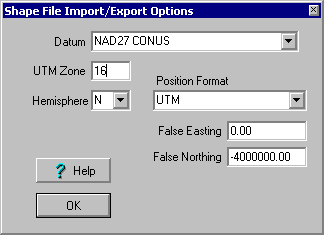
Shape File Import/Export Options
see also Importing ESRI Shape Files Exporting to ESRI Shape Files
Shape files can come with the positions within the file stored in various formats. To import the shape file correctly you must import it by specifying the correct Position Format. OziExplorer supports some common formats.
Datum - The Datum the positions in the file are referenced to.
UTM Zone - The zone the positions are located in. If the positions in the file are in UTM and you select the UTM position format then the correct zone must be entered. If the correct zone is not entered the positions will not be calculated correctly.
Hemisphere - If you enter a UTM Zone you must also indicate if the positions are North or South of the equator.
Position Format - The Format of the positions in the file (the coordinate system used). The shape file has no way to store the zone information of Grid systems so if the UTM format is selected you must nominate the UTM Zone and Hemisphere.
False Easting - Used with the Albers format only.
False Northing - as above.