Sorting by Name or Description - Click the left mouse button on the "Name" column title to sort the waypoints by name. To reverse the sort click again on the title. The waypoints can also be sorted by description.
Datum
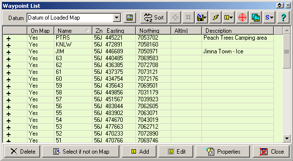
Datum - The datum of the positions displayed in the list.
![]() Sets the Datum to
the Datum of the currently loaded map.
Sets the Datum to
the Datum of the currently loaded map.
If the Datum of Loaded Map is selected then the datum used will always be the same as the datum of the currently loaded map. To see the datum of the loaded map place the mouse pointer on the field and the datum will be displayed as a hint.
Buttons
![]() Sort - Sorts
the Waypoints permanently into alphabetical Name order. Save the Waypoint file
if you want the changes kept.
Sort - Sorts
the Waypoints permanently into alphabetical Name order. Save the Waypoint file
if you want the changes kept.
![]() Position Format Buttons - Show the
positions in Degrees or the selected Grid. The Grid will change to reflect whatever
Alternate Grid system you have chosen in the Configuration.
Position Format Buttons - Show the
positions in Degrees or the selected Grid. The Grid will change to reflect whatever
Alternate Grid system you have chosen in the Configuration.
![]() - Save selected waypoints to file.
- Save selected waypoints to file.
![]() - Send selected waypoints to the GPS.
- Send selected waypoints to the GPS.
![]() - Allows you to change the
Font Size, Style, Color, Symbol,
Display Format, Pointer Direction, Proximity Distance or the Garmin GPS Display Format for All selected waypoints.
If the OziExplorer3D add-on has been installed, Altitude can be added to the
selected waypoints if Height Data is available for the region of the map.
- Allows you to change the
Font Size, Style, Color, Symbol,
Display Format, Pointer Direction, Proximity Distance or the Garmin GPS Display Format for All selected waypoints.
If the OziExplorer3D add-on has been installed, Altitude can be added to the
selected waypoints if Height Data is available for the region of the map.
![]() - Plot
Location of Selected Waypoint on Current Map - Will position the current map so the
Waypoint is in the center of the screen.
- Plot
Location of Selected Waypoint on Current Map - Will position the current map so the
Waypoint is in the center of the screen.
![]() - Find
Map for Selected Waypoint - Will find all maps which can display the waypoint,
see Find Map help for details.
- Find
Map for Selected Waypoint - Will find all maps which can display the waypoint,
see Find Map help for details.
![]() - Selection functions, none, all, invert.
- Selection functions, none, all, invert.
Delete - Deletes the selected waypoints.
Select if Not on Map - Selects all Waypoints which will not plot on the currently loaded map, they can then be deleted or another action performed.
Add - Manually Add a new Waypoint.
Edit - Edit the selected Waypoint.
Properties - Opens the properties window for the selected Waypoint, a double click on the waypoint also opens the properties window.
Close - Closes the Waypoint List. If you have made any changes to the Waypoints you will be reminded to save the Waypoint file.
Editing Waypoints
There are 2 ways to edit waypoints from within the Waypoint List.
Select the waypoint and press the Edit Button - this gives an editor where only the major properties are available, this is the preferred method for editing waypoints quickly.
Select the waypoint of press the Properties Button - this gives access to all the properties of the waypoint.
Adding Waypoints
To add a new waypoint to the current list press the Add Button - this will open up the Add/Edit Waypoint window where the major details of the waypoint can be entered. To set the other properties of the waypoint you must first add the waypoint and then select the properties button to open the properties window.
Add/Edit Waypoint Window
This section describes the fields in the window.
Name - The waypoint name
Position Fields - These are entered using the same coordinate system you have selected in the waypoint list.
Altitude - The altitude of the waypoint.
Description - The description of the waypoint.
Symbol - The symbol to use.
Position Datum - This is the datum you were using when you obtained the position of the waypoint you are now entering. The coordinates will be converted from this datum to the datum of the current map.