Turn your Laptop or Netbook into a
navigator !!!
![]()
What you get -
OziExplorer GPS Mapping Software running on your laptop, and with a suitable GPS Receiver connected, will show your current position on a 250k map of Australia - all you need to get started - with real time tracking operational in your 4WD. (That's OziExplorer + 250k Australia wide map). Note : For real time tracking a GPS is required. A suitable GPS can be purchased quite cheaply from eBay ($50-$70)
|
All this for only $140
(Australian dollars) (includes GST)
1 x OziExplorer GPS Mapping Software See our Australian Purchase Page for availability (Click here) |
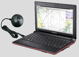 |
* Note: We recommend the GlobalSat GPS Mouse (USB) BU-353-S4 GPS which connects via USB. Our experience is that the USB type GPS is more reliable and has other advantages over the equivalent bluetooth models. Our experience is that the latest G-STAR IV has the ability to obtain a fix on the satellites faster and stronger than previous models.
What you are required to have -
A Laptop, Netbook, Tablet, UMPC (or other mobile PC) running Windows O/S ** and with a USB or Bluetooth Port to connect a GPS.
** Windows 95 / 98 / ME / NT4 / 2000 / XP / Vista / 7 / 8 / 8.1 / 10 (both 32 bit and 64 bit versions)
Note: We recommend the GlobalSat GPS Mouse (USB) BU-353-S4 GPS which connects via USB but a suitable bluetooth GPS can also be used.
How it works -
With OziExplorer running and a GPS connected to the laptop / netbook / tablet PC (or other mobile PC), the position received from the GPS is plotted on the map providing real time tracking ability as you travel (this can also be called Moving Map). When you leave a map OziExplorer automatically changes to the next map. The track you travel can be logged to file for permanent storage of your travels. The 250k Australia map covers all of Australia.
OziExplorer GPS Mapping Software Features -
For all the features OziExplorer provides, see the "Features" page click here