The 3D Control is used for the creation of 3D maps for use in OziExplorer3D
The creation of 3D maps assumes you have elevation data installed which covers the area of the map you are using.
Use this Control to create a map or part of a map for display in OziExplorer3D.
Buttons
Draw Box to Set Limit of 3D Map - This allows a box to be drawn on the map. The area inside the box can be processed to create a 3D map for display in OziExplorer 3D. To create larger areas of the map use the zoom function in OziExplorer to zoom out first. Note - In unregistered versions of OziExplorer the creation of 3D maps can only be done at 100% zoom.
Create the 3D Map - After selecting the map limits (above) the 3D map will be compiled and transferred to OziExplorer3D.
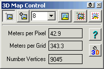
Grid Size - The grid spacing (in image pixels) use to create the 3D map. When compiling the 3D map an elevation is taken at these points. The grid spacing determines look of the 3D map.
Select Viewing Window - The current viewing window will be selected. Note - This option is disabled in unregistered versions of OziExplorer.
Select Full Map - The full map will be selected. Note - This option is disabled in unregistered versions of OziExplorer.
Select Inside Corner Markers (Neat Line) - The map area inside the corner markers (map neat line) is selected.
Note - This option is disabled in unregistered versions of OziExplorer.
Configuration - Opens the Configuration dialog. There is separate available for configuration.
Fields
Meters per Pixel - The approximate number of meters per pixel for this map.
Meters per Grid - The number of meters per grid for the grid size specified.
Number Vertices - The number of vertices (grid points) that will be created. The number of vertices determines how the 3D map will look. The number of vertices also determines the performance (usability) of the map in OziExplorer3D. Too many vertices will affect performance.