The creation of a Track Profile assumes you have elevation data installed for the map you are using.
The Track Profile allows a track to be created along a defined straight line. The altitude for positions along this line are determined and stored with the track points for later display.
The created Track Profile is just a normal OziExplorer track and can be manipulated using the standard track methods.
Fields
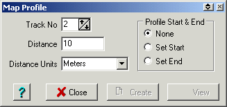
Track No - When a profile is created it will be placed in a track, this specifies the track number to use.
Distance - The distance to use between each track point as the track profile is created. A smaller distance unit means more track points will be created.
Distance Units - The units for above.
Profile Start & End - This sets the start and end of the profile. Press the "Set Start" option and click on the map to set the start position. The "Set End" button will automatically become active, click on the map again to set the end position. The Create button can then be pressed to create the track and the View button can be pressed to view the track.
Buttons
Close - Close the window.
Create - Create a track of the profile.
View - View the created profile on a profile graph.
Help - Provides this help.