The display of Elevations assumes you have elevation data installed for the map you are using.
The Elevation Display window shows the Elevation under the mouse position.
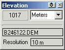
Fields
Altitude - Displayed in the unit specified.
File Name - The name of the file used to obtain the elevation for this position.
Resolution - The distance between elevations (the grid spacing) in the above file.