OziExplorer
3D -
FAQ
General Information
- OpenGL and Windows Operating System
OziExplorer3D uses the OpenGL graphics engine for
high-performance 3D graphics similar to the engine used in many of the video games. Most video
card manufacturers support OpenGL, but to get the best performance from your
computer it is important to make sure you have the most recent drivers. Hardware acceleration of OpenGL requires special drivers which take advantage
of the graphics hardware in the system.
- What if I only have a basic graphics card
and my maps rotate slowly
If your system does not have a graphics card
with hardware acceleration, the software will perform slowly. The reason for
this is that although most Windows users will have access to
a software implementation of OpenGL, it uses the CPU (instead of a dedicated
graphics card) to render 3D graphics. Windows 95B (OSR2/2.1), Windows 98 and
Windows NT 4.0 all ship with Microsoft software implementations of OpenGL.
If you select "Wire Frame Rotate" in
OziExplorer3D configuration, the software will operate better on your system
when you drag or rotate your map. Use of smaller map sections with less vertices
will improve performance.
- Will 3D graphics cards improve the
performance of OziExplorer3D
Yes, if you have a graphics card with built-in
opengl 3D support you will get an improved performance from one without. However, you should
obtain specialist advice on which graphics best suits.
FAQ
- I have DEM files which are projected in the local
Grid and map datum, how can I use these.
OziExplorer has the ability to specify the grid and
datum being used, see the Height Data help
(bottom of the page) for information on how to do this.
- When I select the "whole map" my computer
is very slow.
1. Try selecting a smaller section of the
map, some computer systems will not be able to handle selection of the whole
map, particularly if the map is large.
2. Reduce the number of vertices. Some
computer systems will slow down if you have 10,000 or more vertices.
3. If you select "Wire Frame Rotate" in
OziExplorer3D configuration, the software will operate better on your system
when you drag or rotate your map.
- My track elevation does not correspond
with the map elevation pattern (shape).
1. The height datum of the track elevation
data and the DEM elevation data may be different.
2. The map will show the elevations at the
accuracy of the data from the DEM file. Also the grid spacing of the data will
have an effect. (eg Gtopo30 data is 1km grid spacing which will tend to smooth
out the map elevation shape).
3. The track height data captured by a GPS is
not accurate.
There are two elevation offsets you can make
- In OziExplorer / Elevation Configuration,
you can enter an "Elevation Adjustment" value (m). This will adjust both
your Track heights (from GPS) and your map elevations from your DEM files.
- In OziExplorer3D, the "Elevation Offset"
on the Map Control allows you to adjust your 3D map elevation.
- Can height data captured by my GPS with a
track be used to replace DEM data for my map.
If height data is downloaded with the track
then it will be used in the track display. It cannot be used to replace the
elevations shown from the DEM data.
- My heights do not agree with the contour
lines on my map
The units (metres /feet) may not be correct,
check that the units selected in OziExplorer are the same as the units the
contour lines are drawn.
We have seen DEM data files with incorrect
data, use the "Elevation Adjustment" in OziExplorer / Elevation Configuration
to adjust the data. (Don't forget to reset the Elevation Adjustment back to
zero).
- My operating system is Windows 95
Windows 95 and Windows 95a users may download
OpenGL Version 1.1 from Microsoft's website. Download it and place the files in
the Windows\System directory. It should fix OpenGL problems with the Win95a
Operating System.
DO NOT run this program unless you have the
original edition of Windows 95 AND you are specifically getting the error
message that you are missing OpenGL32.DLL.
Windows 95 OpenGL Update
or
Download Windows 95 OpenGL Update from Microsoft
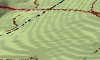
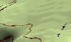
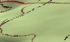
- My map doesn't look smooth, it has ridges
which should not be there
You have turned off
filtering in Elevation Configuration in OziExplorer and then you have "oversampled". In the 3D Map
Control dialog in OziExplorer, the value of the grid delta (metres per grid) is
a lot less than the elevation data grid. Change the grid size in pixels using
the drop down box until the metres per grid value is about equal
or greater than the
resolution of the elevation data.
 |
 |
 |
|
Over sampling |
Normal |
Under sampling |
- It is taking a long time to create my 3D
map
The number of vertices is too many for your
computer system to process quickly. Reduce the number of vertices by increasing
the "metres per pixel" or select a smaller area of the map. Older computer
systems will have difficulty processing more than
approximately 10,000 vertices.