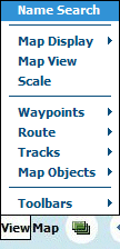
View Menu Options
Name Search - Shows the Name Search dialog - see the Name Search help for details.
Map Display - Options to change the map display mode.

Course Up - If ticked, when GPS tracking is on, the map will rotate so the direction of travel will be within roughly 45 degrees of vertical as the map is only rotated in 90 degree increments to keep performance reasonable.
3D Perspective View - If ticked, this rotates the top of the map down using a true perspective view and provides for more map view ahead.
Map View - Shows/hides the map view window which displays the full map.
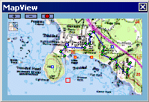
![]() Use the buttons to change the map view window size.
Use the buttons to change the map view window size.
![]() Show/Hide
the display of objects (Waypoints, Routes, Tracks and Map features) on the
MapView.
Show/Hide
the display of objects (Waypoints, Routes, Tracks and Map features) on the
MapView.
Clicking on the Map View map will scroll the main map to the same position.
Waypoints, Routes, Tracks and Map Features are displayed.
Click on the colored border around the map to display a list of the available maps at that position.
Scale - Shows/hides the Scale bar.
![]()
Click and hold on the scale to drag the scale window to a new position.
Waypoints
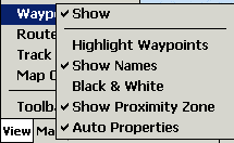
Waypoints / Show - Turn the waypoint display on and off.
Waypoints / Highlight Waypoints - Shows/hides the waypoint highlight which is a large bold circle drawn around each waypoint.
Waypoints / Show Names - Shows/hides the waypoint names.
Waypoints / Black & White - The waypoints will always be drawn in Black & White.
Waypoints / Show Proximity Zone - Show the proximity zone which has been specified (in PC OziExplorer) for the waypoint.
Waypoints / Auto Properties - When a new Waypoint is created the properties dialog will automatically display to allow editing.
Routes
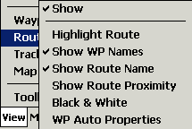
Routes / Show - Turn the route display on and off.
Routes / Highlight Route - Shows/hides the route waypoint highlight which is a large bold circle drawn around each waypoint.
Routes / Show WP Names - Shows/hides the route waypoint names.
Routes / Show Route Name - Shows/hides the route name.
Routes / Show Route Proximity - Shows/hides the proximity zone around a route waypoint. The proximity zone properties are set up in Configuration / Route.
Routes / Black & White - The route and route waypoints will always be drawn in Black & White.
Routes / WP Auto Properties - When a new Route Waypoint is created the properties dialog will automatically display to allow editing.
Track
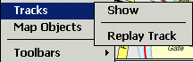
Track / Show - Shows/Hides the display of the Tracks on the map.
Track / Replay Track - Loads a Track file but does not display it immediately. Replay it using the Start NMEA communication button. I actually coded this as a sort of NMEA simulator.
Map Objects
![]()
Map Objects - Shows/Hides the display of Map Features and Map Comments on the map.
Toolbars
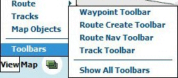
Waypoint Toolbar - Shows or removes the toolbar for creating or modifying waypoints. (view)
![]()
Route Create Toolbar - Shows or removes the toolbar for creating or modifying routes. (view)
![]()
Route Navigation Toolbar - Shows or removes the toolbar for route navigation. (view)
![]()
Track Toolbar - Shows or removes the toolbar for creating or modifying tracks. (view)
![]()