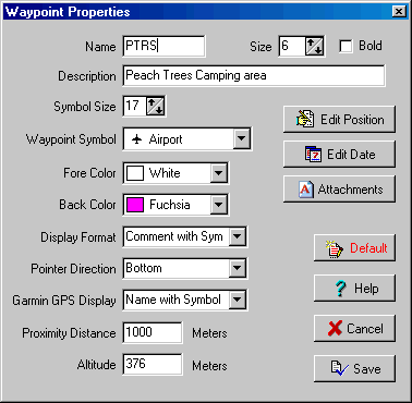
Waypoint Properties
Fields
Name - The name assigned to the waypoint. The length of the name depends on the model of GPS configured and can be set in GPS configuration. There is usually a limitation of what characters can be used in a waypoint name, check your GPS and/or GPS manual for these.
Size - The size of the font used to display the waypoint on the map.
Bold - Determines if the font is displayed with bold characters.
Description - The description of the waypoint.
Symbol Size - The size the symbol will be drawn on the map. 17 is the normal size of the symbol and this is the size where it will look natural. reducing the size below 17 will result in lost pixels from the symbol and an inferior image.
Waypoint Symbol - Select the symbol from the list provided. The list of symbols provided depends on the symbol set available for the GPS which has been specified in the configuration.
Fore Color - The foreground color of the event symbol.
Back Color - The background color of the symbol.
Display Format - For the map display of the waypoint only, select the display format type. Has no affect on the GPS waypoint display format.
Pointer Direction - The direction the pointer or symbol is located from the waypoint name. This is dependant on the display format which has been selected.
Garmin GPS Display - For Garmin GPS receivers only. Specifies the default way the waypoint is to be displayed on the GPS plotter screen. Not all Garmin models support the feature.
Proximity Distance - The proximity distance is used when using moving map mode (real time tracking). If your position moves inside the waypoint proximity an alarm is sounded. This proximity is not uploaded to the GPS and has no affect on the GPS at all.
Altitude - The Altitude of the waypoint. The units used can be specified in OziExplorer configuration. If the GPS supports it the altitude can be uploaded and downloaded from the GPS.
Buttons
Edit Position - Opens a dialog where the position of the point can be edited.
Edit Date - Opens a dialog where the date assigned to the waypoint can be edited.
Attachments - Allows files to be attached to a waypoint - see Waypoint Attachments help for details.
Default - Saves the currently set waypoint properties as the defaults used when new waypoints are created. The Name, Description, Proximity Distance and Altitude are NOT saved as defaults.
Help - Gives help for the properties dialog.
Cancel - Close the dialog and discard any changes.
Save - Close the dialog and keep the changes.
If you make any changes to the waypoint you must save the waypoint file to make the changes permanent.