Map Features
Map Features are objects which can be placed on a map, they are used to show the position of places or features of interest. They can be displayed as a blue circle with a number or as a symbol which the user can select.
A link to a picture file can also be added to a map feature and the picture is displayed with the map feature in the properties dialog.
Map Features are saved in the map file.
There is limit of 500 map features per map.
Creating Map Features
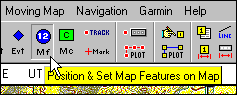
Select the Position & Set Map Feature button on the toolbar. The cursor will change to a cross hair when it is in the map area.
Select the position on the map where you want to place the map feature and press the left mouse button.
Editing the Properties of Map Features
To open the property dialog for a map feature either double click on the map feature object or right click with the cursor on the map feature object and select the properties option on the menu.
The properties of a map feature can be modified in the properties dialog, see Map Feature Properties for details.
Map Feature Symbols
A map feature can also be displayed as a symbol, extra symbols can be created by the user.
See Map Feature Symbols for details.