
 for
PC computers
for
PC computers
OziExplorer3D
Mapping Software for PC
This is the official web page for the OziExplorer3D Mapping
Software which will display 3D maps created by OziExplorer and can be
manipulated in real time.
OziExplorer3D is an add-on for OziExplorer GPS Mapping Software.
 |
|
|
 |
|
|
 System Requirements
Windows 95/98/ME/NT4/2000/XP/Vista/7/8 & 8.1/10 with OpenGL support (this
is standard for all except Windows 95). A graphics card with OpenGL hardware and driver support is
preferred for performance reasons but is not essential OziExplorer GPS Mapping Software OziExplorer3D Software Height Data for the regions of interest
Computer systems with 3D graphics cards with acceleration will
obtain better performance. OziExplorer3D uses OPENGL programming which is
highly dependent on your graphics card drivers. It is expected some
systems will have problems because of this. |
|
|
|
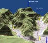
OziExplorer3D is software which allows map images to be viewed in 3D with
the ability to rotate in all directions and zoom in and out of the view.
When the term OziExplorer3D is used the 3D map viewer is being
referred to, when the term OziExplorer is used the OziExplorer GPS
Mapping Software is being referred to.
|
|
The 3D maps are created using the OziExplorer GPS Mapping Software, the 3D
maps are then viewed by OziExplorer3D, in this respect OziExplorer3D can be
considered as an add-on to the OziExplorer GPS Mapping software.A 3D map can be created from any map that can be loaded in OziExplorer
provided you have elevation data for the region.
A 3D map is composed of a map image (or image part) and a grid of heights at
a spacing specified by the user. The software plots the height grid in 3D
and then overlays the map image on the grid (this is called texturing) to
produce a 3D map. OziExplorer creates the grid of heights
using the height data you have obtained and writes this to a file. Other
required information is also written to the file and the file is then passed
to OziExplorer3D which loads the file and the map image (or image section) and
displays the 3D map.
The evaluation version of OziExplorer3D will work with the
evaluation version (shareware/demo version) of OziExplorer
but the limitations of both packages will apply.
To get the full benefit of
creating and viewing 3D maps you
must have a purchased copy of OziExplorer3D and a purchased copy of
OziExplorer.
Main OziExplorer3D Features
There is a detailed list of
features here
- Display maps in 3D.
- Most
maps which can be viewed in OziExplorer can be viewed in 3D (some image
types are excluded for licensing reasons).
- Rotate
your maps in 3D, view from any direction.
- View waypoints, tracks and points on the 3D map.
- Zoom in and out.
- Apply 3D shading to your map * Apply Fog to the map.
- Load multiple maps in OziExplorer3D (purchased version only).
- Show GPS position on the 3D map.
- Save, copy to the clipboard and print the current 3D map view.
- + much, much more.
|
|
|
 |
|
|
 |
Design Philosophy
Because OziExplorer can handle maps and also requires the use of height data
for its own needs it was decided to include the creation of the 3D maps within
OziExplorer rather than duplicating its map handling functionality in
OziExplorer3D as well. OziExplorer can use a normal OziExplorer map and the
height data which the user has installed to create a 3D map file which is then
sent to the OziExplorer3D map viewer.
Download
History of Changes
 Click here to
download the Evaluation Version of OziExplorer3D (Version 1.14)
Click here to
download the Evaluation Version of OziExplorer3D (Version 1.14)
Note Note Note : Version 3.95.0 (or later) of OziExplorer is required, OziExplorer3D will not work
with any earlier version.
Help File in Spanish (Espańol)
Help File in
Italian (Italiano)
Purchase OziExplorer3D
Limitations of the OziExplorer3D Evaluation
Version
- Nag screen pops up whenever a new map is loaded
- Limit of 1 window open at a time (purchased version has no limit (system
limitations apply))
- Limit of 100,000 vertices
- Lighting and Fog parameters cannot be adjusted
OziExplorer Shareware/Demo and Trial
Versions
This only lists those limitations which apply to creating 3D maps, other
limitations may also apply.
- 3D maps can only be created at 100% zoom
- the ability to select the full map and the map inside the neat lines are
disabled
Online Help File
OziExplorer3D Help File Online - This link
displays the OziExplorer3D Help and is recommended to help get the most out of
OziExplorer3D.