|
Home | Ozi Home | Features | Screen Shots | Optional Extras | Development | GPS FAQ | Support | |
UPDATE:
Terraserver have changed their domain and also now appear to use an encrypted link to the tiles. Terraserver maps no longer will load. We do not know at this stage but are looking into whether continued support is possible.
Suggested work around is to use Internet Maps.
-------------------------------------------------------
This page describes how to use the USA Terraserver Maps with OziExplorer.
The use of Terraserver Maps within OziExplorer can be considered experimental at this stage.
You need an internet connection to use USA Terraserver Maps. The map image tiles are downloaded in real time from the internet and stored in a file cache.
Tiles which have already been cached can be used when offline.
You also need to download the USA Terraserver.map file (see below).
These links provide information about the Terraserver maps.
http://terraserver-usa.com/About/AboutLinktoHtml.htm
http://terraserver-usa.com/cmap.aspx
OziExplorer Version
You must be using OziExplorer release version 3.95.5c. Check the "Help / About" option in OziExplorer to see what version you are currently running.
The OziExplorer development version does not yet work with USA Terraserver Maps but will in the future.
Notes :
*** You need to download the "USA Terraserver.map" file ***
Download self installing setup file - download map file here
Run the downloaded setup file to install the map. It is installed in the Internet Maps folder (under the Maps folder).
Open the "USA Terraserver.map" map file in OziExplorer in the usual way.
Do not try to recalibrate the map or change the map border, there is no need they are fixed in the software.
First you need to open the "USA Terraserver.map" file in the usual way (Load Menu / Load Map File)
(Note: an explanation of the modes is above)
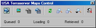
![]() Select Map Region - Switch between continental USA, Alaska and Hawaii.
Select Map Region - Switch between continental USA, Alaska and Hawaii.
![]() Switch
to DRG Topographic
Map
Switch
to DRG Topographic
Map
![]() Switch to Black and White Aerial photo
Switch to Black and White Aerial photo
![]() Switch to Color Aerial photo - this is available for selected urban areas
only, some major urban areas are not available.
Switch to Color Aerial photo - this is available for selected urban areas
only, some major urban areas are not available.
![]() Draw Screen
- Redraws the screen if it has not refreshed properly.
Draw Screen
- Redraws the screen if it has not refreshed properly.
![]() Zoom In - Zooms Google
Maps in to show more detail, click the button
to zoom in.
Zoom In - Zooms Google
Maps in to show more detail, click the button
to zoom in.
![]() Zoom Out - Zooms Google
Maps out to show a wider view, click the button
to zoom out.
Zoom Out - Zooms Google
Maps out to show a wider view, click the button
to zoom out.
![]() Zoom
Level - Select the required zoom level from the drop down menu.
Zoom
Level - Select the required zoom level from the drop down menu.
It can be difficult to move to the location you are interested. If you have waypoints for the area you can load them and use the "Plot Location...." button on the wp list toolbar to move the map the its location.
You could also use Name search if you have a USA database.
Other
Saving of the USA Terraserver Maps map is not possible.