|
Ozi Home | HEMA Maps | 250K Topo DVD | 100K Topo DVD | City Maps DVD | Geology Maps | NSW Boating Maps | links | |
|
=
Special prices
for bundles
=
New Zealand Maps Downloads |
|
Digital Maps available and other information for Australia
(For information on using other map sets with OziExplorer CLICK HERE.)
Hema Australia 4WD Digital Map Collection Maps
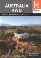 |
The Hema Australia 4WD Digital Map Collection 2020 Maps Purchase from the Buy Now page - you will receive links to download the maps (Important - Click here for the Hema 4WD Map Collection End User License agreement) |
HEMA - Australia 4WD Raster Map Collection
Includes
The new Australia Topo 150K, all of Australia at 150K scale.
More than 90 of Hema's regional and four wheel drive maps which include many different areas such as Cape York, the Top End, Simpson Desert, the Pilbara, Kimberley + many more and also many National Parks.
The maps are in the OziExplorer OZF4 format and can only be used
work with the OziExplorer suite of programs.
These maps can be used with the full version of OziExplorer,
OziExplorer Android and
OziExplorerCE.
|
|
|
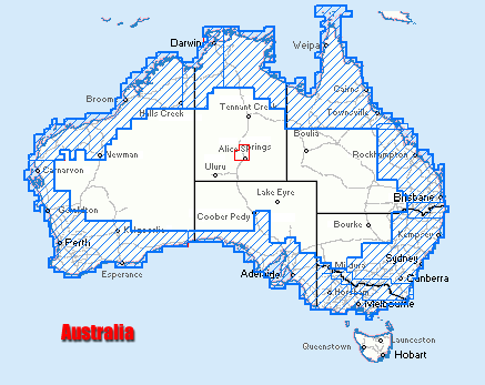
See Map Coverage - Map of Australia showing the coverage of the maps (additional maps have been added, some may have been changed or removed in the 2020 maps).
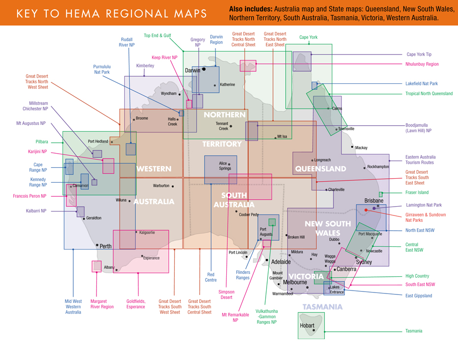
Example map sections -
Hema 150k Seamless
150k section
(This map covers all of Australia)
Hema Regional Maps
Regional section
(More than 90 maps of specific regions of Australia)
One of our Getting Started Packages - Turn your Laptop or Netbook into a navigator !!!
** TRIP PLANNING ** Real Time Tracking **
Package Option 1 - OziExplorer GPS Mapping Software running on your laptop with a USB Mouse GPS Receiver connected showing your current position on a 250k map of Australia - all you need to get started - with real time tracking operational in your 4WD. (That's OziExplorer + 250k Australia wide map). Don't have a GPS, the GPS Mouse Receiver (USB) BU-353-S4 is suitable and can be purchase on eBay for $50-$70.
PC OziExplorer + 250k Maps for $140 (Australian dollars) which includes GST. (Software and maps are downloaded)
More information about this package ( Click here)
Already have a suitable GPS!!! Then this package is perfect, PC OziExplorer and the 250K map can now be download. See our Australian Purchase Page (Click here)
NOTE : GPS is not included. A suitable GPS is the GlobalSat G_STAR IV GPS Mouse Receiver (USB) Model BU-353S4.
GPS Mouse Receiver (USB) BU-353S4 can be purchased from eBay quite cheaply ($50 - $70)
|
250k Maps for Australia | 100k Maps for Australia | City and Town Maps | Geology Maps | NSW Maritime Boating Maps | |
 Australia
Topo 250K Digital Maps download (
Australia
Topo 250K Digital Maps download (![]() maps can now be downloaded)
maps can now be downloaded)
We have developed an Explorer 250K Digital Maps download incorporating data which is � Commonwealth of Australia (Geoscience Australia) 2008. The maps are for use with OziExplorer, OziExplorer Android and OziExplorerCE mapping software.
The primary map is a 1:250K topographic map of Australia in OZF4 format. Also included is a Landsat 7 Satellite map of Australia and a 1 million scale topographic map of Australia, both in ECW format. The maps are mosaic maps covering all of Australia.
The OZF4 is a tiled format optimized for use in OziExplorer, OziExplorer Android and OziExplorerCE GPS mapping software.
More Information about these maps
|
|
Australia Topo 250K Digital Maps download - $39 (Australian dollars) which includes GST. (for bundle deals, see our Australian purchase page - PC OziExplorer + 250K Maps download) |
 100K
Topo Digital Maps (
100K
Topo Digital Maps (We have developed Explorer 100K Digital Map sets for download. These maps incorporate data which is � Commonwealth of Australia (Geoscience Australia). The maps can be used with OziExplorer, OziExplorer Android and OziExplorerCE mapping software. The maps are in OziExplorer OZFx3/4 format suitable for use in OziExplorer, OziExplorer Android and OziExplorerCE mapping software. The OziExplorer calibration files for the maps are included.
Please Note: The base Geoscience Australia data these maps have been produced from is 30+ years old. Some of the map sections have been updated with roads added. There may be roads or tracks in your region of interest which are not on these maps. The original scan quality varies over the map (see the examples on the "More Information" pages). More Information about these maps 100k New South Wales Raster Digital Maps 100k Queensland Raster Digital Maps 100k South Australia and Northern Territory Raster Digital Maps |
||
|
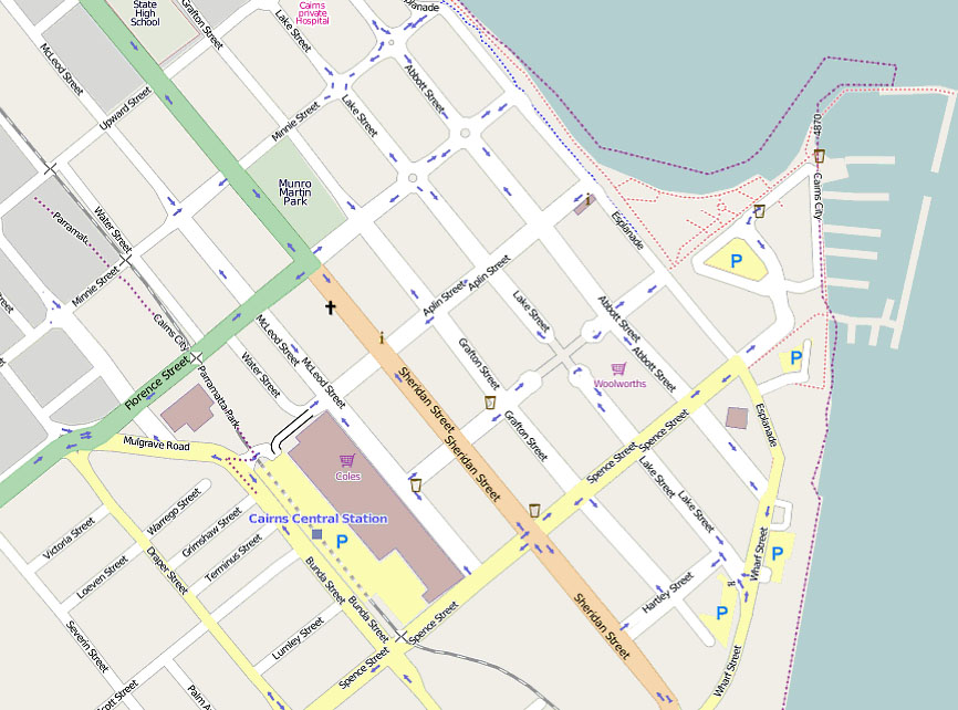
 City and Town Maps download (
We have developed a City and Town street level maps for Australia for download. The maps in the download are designed for use with OziExplorer, OziExplorer Android and OziExplorerCE mapping software. Capital cities and major regional towns are covered. (see below) NEW - Now includes Cycle Maps for the Capital Cities.
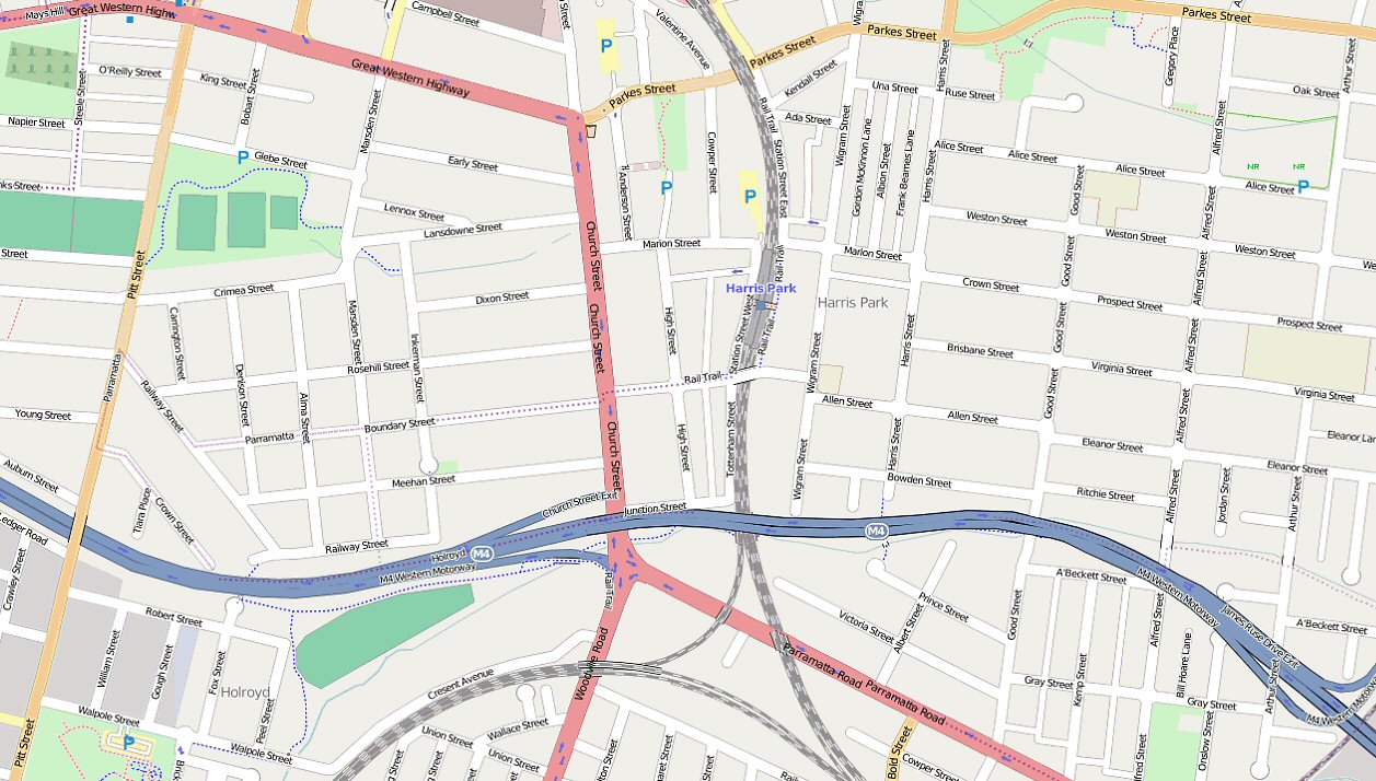
The maps are in OziExplorer OZFx3 format and the OziExplorer calibration files for the maps are included in the download. The City region and Town maps are about 2 metres / pixel. Please Note: The base data these maps have been produced from is Open Street Map Data and Open Cycle Map Data. While the data is generally accurate, there is no guarantee of its accuracy and / or completeness for any given area. More Information about these maps Cities and Towns Covered : Adelaide Region, Brisbane Region (Noosa to Kingscliffe), Canberra Region, Darwin Region, Hobart Region, Melbourne Region (Bell's Beach to South Dudley), Perth Region, Sydney Region. Albany, Albury, Alice Springs, Armidale, Augusta, Ballarat, Bendigo Region, Broken Hill, Broome, Bundaberg, Cairns Region (Cairns to Cooktown), Casino Region (Kingscliffe to Evans Head), Cloncurry, Coffs Harbour, Dubbo, Esperance, Gladstone, Grafton, Innisfail (Ingham to Gordonvale), Kempsey, Longreach, Mackay, Margaret River, Mount Isa, Newcastle to Gosford Region, Port Augusta to Port Pirie Region, Port Hedland, Port Macquarie, Proserpine, Rockhampton, Tamworth, Taree, Tennant Creek, Toowoomba, Townsville, Wollongong Region. Regions : Also includes the following region maps at about 16 metres / pixel - South East QLD, North Coast NSW, South Coast NSW, South East VIC and an overview map of Australia at 30 metres / pixel. Sydney Map Section Sydney Map Section
|
||
|
 250K Geology Maps download (
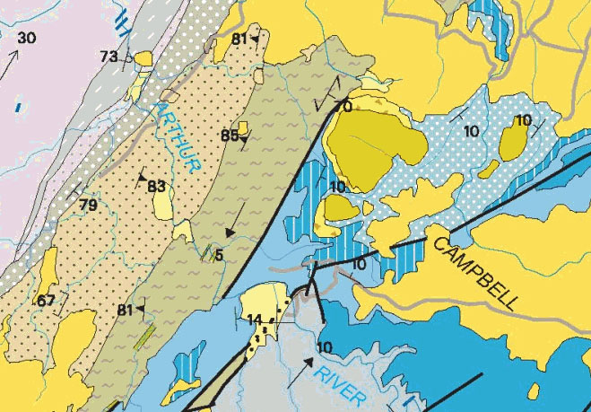
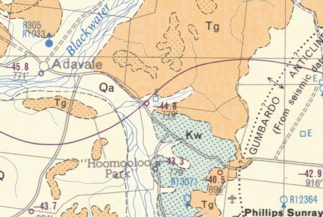
We have developed Explorer 250K Geology Maps incorporating data which is � Commonwealth of Australia (Geoscience Australia) 2008. The maps are on OZF format for use with OziExplorer, OziExplorer Android and OziExplorerCE mapping software. Each state can be purchased and downloaded separately. Queensland (1.7GB download) These 1:250 000 scale geology maps are scanned images in 250 DPI resolution. Each mapsheet includes a legend. The original JPG images can be downloaded from the Geoscience Australia website. First editions were prepared in the 1970's as part of a government program for mapping Australia. Many maps have been updated. (See examples below) The OziExplorer calibration files for the maps are included in the download. Please Note: The original scan quality varies over the maps (see the examples below). Special Note: WINTINNA, SA (SG5314), COOMPANA, SA (SH5215) maps not available. View Map Section A - View Map Section B Check out the maps, full JPG map images (8MB each). (Right click, "Save As" to download) |
||
|
NSW Maritime have released their boating maps in PDF format for download from their website. We have converted and calibrated these maps to our OZF format for easy use with OziExplorer and OziExplorerCE and are providing these maps as a download. The calibrated OZF maps in this download can only be used with OziExplorer and OziExplorerCE.
Click here for more information about these maps.
|
|
NSW Maritime Boating Maps download - $19 (Australian dollars) which includes GST. |
See our Maps Link on the left hand menu for maps on the WWW - (Also some free maps - continental scale)
WESTPRINT - Outback Australia Maps
- Australia Outback Tracks map covering all of Australia and in OziExplorer map format to work with OziExplorer.
- Other more specific region maps - Birdsville, Strzelecki, Canning Stock Route and more are available.
MapTrax - Maptrax closed down in October 2011.
- Supplier of GPS navigators and other equipment including maps.
- Australia's original GPS shop, and one of Australia's premier GPS suppliers.
- Supplier of in-dash navigation systems and other related equipment.
Landgate - Western Australia Land Administration (DOLA)
- StreetExpress are gif or ecw (depending on the version) images that can be imported into OziExplorer.
- Western Australian Digital Nautical Chart Images. This CD contains raster (ECW and TIFF) and PDF (Adobe Acrobat) formats of the Department's Nautical Charts, covering Perth local waters from Lancelin to Dawesville.
Australian Hydrographic Service
The Australian Hydrographic Service has recently added Seafarer GeoTIFF to its digital product range. Seafarer Geotiff are geo-referenced raster images of the Australian Navigational Series in GeoTIFF Format. These maps can be imported into OziExplorer.
Adventurer Maps
(These maps are sold through maps shops in the southern states) Check with the Melbourne Map Centre or Map Centre Parramatta)23 Adventurer Maps on CD (Rooftop Maps), already configured for OziExplorer. Covers Victorian High Country from Walhalla up to Kevington and surrounding areas.
The Fullers Street Directory of Adelaide
Fullers Street Directory (for Adelaide) - comes with .map files for OziExplorer. You also get the bike SA maps and the 75 country towns on the same CD.
Tasmanian Government, Department of Primary Industries - TASMAPS
Supplier of digital maps and other products for camping, four wheel driving and caravanning in Australia.
Supplier of maps. Maps on CD for some regions of Victoria.
Other Australian Links
 "GPS Vehicle Navigation in Australia"
This site provides updates and information about the book. There is also content of interest to anyone who is generally interested in GPS, technology and navigation.
